Since May, the tri-state has been mired in messy weather – long stretches of cloudy, damp and cool weather that seem to fall all too often on the weekend. But the summer solstice and the official start of summer occurs on Friday and, boy, summer will take hold with a vengeance.
It starts with heat and a chance for severe storms on Thursday, followed by a bout of extreme heat that will be a shock to our system – quite literally!
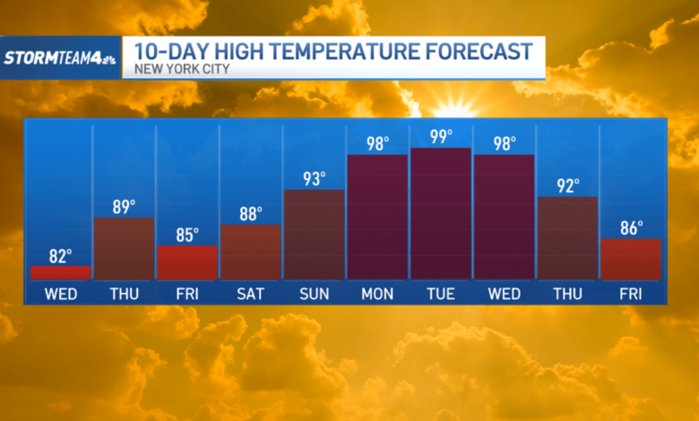
After a relatively cool and cloudy Tuesday thanks to a persistent east wind, Wednesday marks the start of our warm-up. Highs climb into the 80s as winds shift to the south.
By Thursday, a hot southwest wind sends temperatures even higher, to near-90 degrees in New York City. The rapid warm up comes with an increasing storm chance.
On Wednesday, we’ll manage some limited sunshine before isolated storms roll through in the evening. There is a slight risk for severe weather on Wednesday, mainly in Central and South Jersey. If your evening commute takes you along the shore, you might find yourself in a downpour.

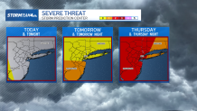
The severe weather risk rises Thursday and becomes an issue for most of the tri-state. The first half of the day will be warm and dry. The lunch hour will be dry, but by the evening commute storms are much more likely, ahead of a cold front approaching from the west.
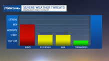
Anticipate periods of heavy rain along with a few rumbles of thunder. Within the strongest storms, damaging wind gusts and even hail are possible. Localized flooding is also a concern where storms are the strongest. Be especially careful when driving down low-lying roads and in poor drainage areas.
The cold front sweeps through Thursday night, ending our rain chances and leading into a much drier Friday. The air behind the front is not cold, either.
Unlike our last few weekends, temperatures will not drop as we head into Saturday and Sunday. In fact, highs will climb back into the upper 80s, even 90s, as a very strong dome of high pressure sets up over the eastern half of the country.
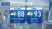
The string of 90-degree days will last much of next week – the first full week of summer – and deliver not only the city’s first 90-degree day of the year, but its first heat wave of the summer season. Right on time!
The high pressure ridge sets up over the eastern seaboard next week and, in addition to keeping us hot, will keep our rain chances away.
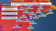
Humidity will be ramping up along with the temperature next week, too, so the “feels like” temperature is going to be wilting. Expect the heat index to be well into triple digits next week – as early as Monday.
This is the type of heat is dangerous, especially because it is coming on so quickly, before our bodies have any chance to acclimate to it. Because of this, be extra careful outside next week. Limit your time outside, limit strenuous physical activity, stay in the shade as much as possible, and drink plenty of water.
Summer is a long season, and we are just getting started.