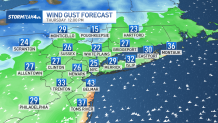
Hurricane Erin is still churning in the Atlantic Ocean as a Category 2 Hurricane, delivering tropical storm force winds to Turks and Caicos and parts of the Bahamas. As the storm continues to make its way north up the east coast, we will see Erin’s influence increasingly felt in the tristate throughout the latter half of the week.
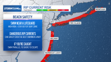
Area beaches are already facing a high rip current threat, mainly due to a persistent easterly wind. But we will continue to see a high risk for dangerous rip currents continue through the remainder of the week, especially as Erin passes offshore on Thursday.

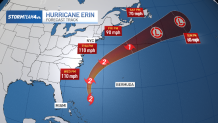
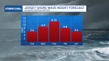
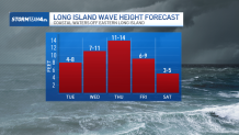
Erin should remain a Category 2 storm as it makes its closest approach to the tristate. Waves will peak on Thursday, though we’ll start to see high surf conditions kicking in as early as Wednesday morning.
Wednesday’s waves could reach heights up to 10 feet, while Thursday’s surf could top off at 15 feet for spots along Long Island.
These high surf and dangerous rip currents will make for an extremely hazardous situation in the water. Stay out of the ocean this week, even when a lifeguard is on duty. The rip currents and surf conditions will be detrimental to even the strongest swimmers.
Cooler temperatures this week will keep the ocean from being too enticing, which is good. Highs will be more in line with early autumn, in the low to mid 70s. Cloudy skies coupled with scattered shower chances through Thursday morning will also keep you from wanting to get into the water.
But by Friday, when we’re back to sunny skies and more seasonable temps, we’ll still be dealing with less-than-ideal surf conditions; it would be best to stay out of the water at least until the weekend.
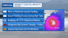
In addition to the rip current threat, Erin will prompt coastal flooding and beach erosion. Coastal flood statements were issued Monday for the evening’s high tide, with minor flooding possible in low-lying areas.
But as the week goes on, we’ll see coastal flooding intensify from minor to moderate levels, exacerbated not only by Erin’s nearby influence, which will further ramp up our easterly wind, but also the upcoming new moon on Saturday.
Erin may not be making landfall, but that does not mean that it can’t have an impact on the tristate even as it stays hundreds of miles offshore. Plan the rest of your week accordingly; it would be a best practice just to avoid the beach altogether the next couple days.